Wednesday, June 30, 2010

Hurricane Alex

Hurricane Alex 6-30-10 at 13-23
1st Hurricane of the Atlantic season.  We just missed this one on our Florida Vacation.


Hurricane ALEX Public Advisory


Home   Public Adv   Fcst/Adv   Discussion   Wind Probs   Maps/Charts   Archive  

US Watch/Warning   Storm Surge  

000
WTNT31 KNHC 301750
TCPAT1
BULLETIN
HURRICANE ALEX INTERMEDIATE ADVISORY NUMBER  20A
NWS TPC/NATIONAL HURRICANE CENTER MIAMI FL   AL012010
100 PM CDT WED JUN 30 2010

...LARGE HURRICANE ALEX...A LITTLE STRONGER...AIMS AT THE NORTHERN
MEXICO AND SOUTHERN TEXAS COAST...  


SUMMARY OF 100 PM CDT...1800 UTC...INFORMATION
----------------------------------------------
LOCATION...24.4N 96.2W
ABOUT 110 MI...175 KM ENE OF LA PESCA MEXICO
ABOUT 130 MI...210 KM SSE OF BROWNSVILLE TEXAS
MAXIMUM SUSTAINED WINDS...85 MPH...135 KM/HR
PRESENT MOVEMENT...NW OR 320 DEGREES AT 12 MPH...18 KM/HR
MINIMUM CENTRAL PRESSURE...962 MB...28.41 INCHES

Hurricane Alex Brownsville Base Reflectivity 6-30-10 @ 13-32

Saturday, June 26, 2010

Long Road Home

Day Map, Thursday 24 June 2010 Part 2

We left New Orleans about 7 p.m.  We headed north on the dreaded interstates for speed and time.  We wanted to get home in time for me to rest up for my early morning at work on Saturday.  We really pushed it to get at least half way to home by morning, which ended up taking us to a truckstop at a small town in the Missouri boot heel.  Mississippi is a long boring drive normally, and even more so at night.  I've taken this route several times in my life.  The first time was in January 1978.  The BeeGee's were constantly driveling on every radio station and disco was in full swing.  I also remember Paul Simon being played a lot and there was a song -- 50 ways to leave your lover, that kept being played over and over again.  We stopped over at a cheap motel in Sardis Mississippi, and I remember it having the softest nicest bed I've ever slept in.  The next morning we all got up to an ice storm.  The weather got worse the farther north we went.  We had lunch in Sikeston Missouri.  Somewhere south of St. Louis, Mom and Debbie, my sister, who were following us in the 74 Ford Gran Torino spun out at a slick spot and got nearly stuck.  Dad, the dog Rebel, and I were in the 72 dodge pickup in the lead.  We bypassed St. Louis, which I've noticed is a path we took today.  We stopped at another truckstop somewhere midway between Kansas City and St. Louis for dinner.  I remember that truckstop food was good back then.  I also remember how hard it was snowing, which was novel for us who lived primarily in the south where it rarely snowed.  I stood under an awning at the truckstop and a big pile of snow fell off the eave and landed on my head to my amusement.  As we headed farther west, the Dodge truck's heater started failing.  I and the dog, Rebel had to curl up together for warmth and try to sleep.  We got into Kansas City early in the morning and the temperature was twelve below zero.  We checked in the Holiday Inn at Harlem, which was a run down neighborhood by the downtown airport just north of the river.  I remember it being unbearably cold and the city seemed depressing and grey.

    Thirty two years later, Suyen and I made the same trek, in another Dodge truck, with our dog, Tima.  We didn't check into that motel in Sardis, though I did glance over to see if it was there.  We stopped over in Steele Missouri after blowing through Memphis without stopping, and Arkansas -- definitely without stopping.  All the rest areas in Mississippi were closed, except one.  Arkansas didn't have any rest areas.  I didn't feel like stopping anywhere close to West Memphis anyway.  We slept in the truck in a truckstop in the Missouri boot heel.
Day Map Friday 25 June 2010
   We got up the next morning, took off, and I stopped at a Caseys for breakfast pizza.  We passed by Sikeston, and I looked for that truck stop.  I think it is long gone, replaced by chain motels.  We only stopped once after that, south of St. Louis for fuel at St. Genevieve.  We bypassed St. Louis all together on ring highways, which was alright by me.  St. Louis is not much to look at from the interstate and traffic there is a nightmare any time of day.  We blazed across I-70 back to familiar territory.  We stopped in KC at a gas station so Suyen could pee, and we got home late in the afternoon.  Not bad for being in New Orleans the evening before.

We had treked across the heartland of the former Confederacy and had seen many pine trees.  We didn't hit the major touristy spots in Florida, but we had a nice relaxing good time.  You know you've had a good vacation when you are happy to be back home.

Biloxi to New Orleans

Day Map Thursday 24 June 2010

We hit one last beach, and that was Biloxi beach.  Actually, when I lived here in the 70's, I don't remember us going to the beaches here, except to fish.  We even went fishing one night on a long dark cold pier after watching the movie "Jaws."  That was scary.  Oh, and I remember us going sand dune fishing at low tide in the darkness of night.  That too was scary.  The beaches here are severely under rated, which is just fine for me.  I like this better than the overcrowded Florida beaches where the resorts and condo's blot out the view of the beach.  Here it is laid back, with gorgeous southern homes and mansions on one side of HWY 90 (well what's left of them anyway after Katrina), and unobstructed beachfront on the other side.  Before Katrina, there was Camille.  I've often heard stories about how this area was called the Riviera of the coast.  Then Camille came and wrecked the shoreline and devastated the towns here.  Growing up here, and dealing with many threats from hurricanes often brought the stories about Camille and the documentary, that played on tv every time a hurricane came close.  Suyen and I went to the beach by the light house where I was the night before.  

IMG_9530
IMG_9535
A reporter from WLOX showed up to do a story on the oil slick, and its effect on the shrimping industry.
IMG_9567

After the beach, we headed to a souvenir shop, then to a place called the Blow Fly Inn, which we had seen on food network.

We then headed over to check on the house I used to live in -- sturdy Base housing brick duplexes that were mid-century modern style ranch houses joined at the carports with their neighbors.  They were gone when we got there -- replaced by condo style duplexes.  We then headed up the coast on scenic highway 90.  Katrina really did a number on the coast here, and it still hasn't recovered after 5 years. 


We drive in to New Orleans from the east.  We were headed for Cafe du Monde for beignets.  We tried to find a place to park in the french quarter, and in the process drive down Bourbon Street, which was fun.


Thursday, June 24, 2010

Beaches

Day Map Tue 22 June 2010


We didn't have time to rent a charter and go diving to possibly, but probably not, see manatees, so we headed north into the pan handle of Florida after eating at a mom and pop restaurant...
We opted to stay away from the boring, stressful, usually jammed up highway like the garmin wanted us to take, and instead hugged the seashore as best we could...
x
We passed many summer cottages and nice beaches.  We wondered often how this area would do during a serious hurricane.  We came to Panama City in need of fuel for Betsy.  We explored the city and the beach front.  We had to try to gas stations as the service was so unfriendly at one that we opted for another.  We then stopped to eat at a bay front open porched seafood place -- finally.
Suyen kept reading online about a place called Panama City Beach, Florida, not to be confused with town of Panama City Florida.  There are a lot of little municipalities stuck together out here, so it gets confusing.  We found Panama City Beach, Florida, after searching, and found a long party beach with many resort hotels and tourist traps.  We found a neat 1950's mid century modern googie place to stay called the Plaza Motel, which bills itself as the "last of the past."  
IMG_9307
You could imagine that at one time this strip was lined with motels like this one.  We actually loved this motel.  It was cheap, cozy, centrally located, and quiet.  It had a lot of the charm of the past too.  The room we were in had been redone, and showed a few signs of being threadbare, but that added to the charm.  I love the check in lobby, with the old coke machines and juke box plus a photo album they had of former guests.   We checked in, rested up a little, and went walking on the strip.  You could tell this was a pary beach by all the drunk college aged kids, or younger driving up and down the strip woo wooing, flashing, peeling out and generally showing off.  There are a lot of not so cheap resort hotels and condo's in this area, and they often blot out the view of the beach.  We went shopping for souvenirs and a bikini for Suyen for the next day.  One big souvenir shop was a place called Alvin's Island.
IMG_9383
The next day we got up fairly early for a morning stroll and dip in the beach.  We had to leave poor Tima in the room as the beaches here don't allow dogs.  The waves were quite strong.  I have a paranoia about sea creatures and beaches, and sure enough, I saw a huge stingray swimming near us.  However, I got over it.

We checked out, and headed for the dog beach with Tima.  We et at a buttfey place first, which was so so.  Then we headed to the dog beach.


IMG_9511
IMG_9505
We didn't  have any time for the big mall by where we were (thank Ghod) er, I mean, Suyen was really disappointed.  

We headed up the coast to Alabama, and Mississippi after stocking up on groceries for the ride...

Day Map Wed 23 June 2010
I took the long way via the beach roads, as much as I could.

We drove through Pensacola, we didn't stop, but someday I'd like to.  We found out later that oil had come ashore at Pensacola on the day we drove through, and the beaches were closed to the public.

We only stopped at a gas station for a bathroom break.  We then headed into Alabama.  Suyen was harping that we didn't have any Florida pictures of us, so I stopped on the state line.  She didn't want to get out though for fear of alligators.
IMG_9517
The pan handle of Alabama was a much longer drive than I thought it would be.  We passed through some small towns, and each seemed to have thriving art communities by the looks of the galleries we passed...


We then came to Mobile bay, and Mobile Alabama.  I have memories of this place from the 1970's.  We would rarely visit this area, but when we did, it was usually to visit the USS Alabama.

We then got on I-10 -- it was inevitable.  We took it to Ocean Springs, where I hoped to eat at a BBQ place featured on the food network.  However, unfortunately, we arrived 10 minutes after closing.

We drove through Ocean Springs, Mississippi, and on into Biloxi to look for a motel.  We found one that had been relocated by Hurricane Katrina.  Actually, the old Broadway Inn Express had been destroyed, and the replacement was pretty much brand new.
IMG_9526
We settled in for the night, save for me driving up HWY 90 with Tima to take care of bidness.  We went to the lighthouse, and I was going to try some night photography, but I forgot the media card.   It was just a well, because it seemed like a lot of scary lowlifes hang out on this part of the beach at night.


Tuesday, June 22, 2010

Ringling Museum, Exploring Tampa Bay and Up the West Coast of Florida

Today, our last day in Sarasota, we had many false starts, as we did heading this way on Thursday.  We met up with Stella and family, then we headed to the one art/museum/cultural bit of tourism we've done on this trip -- the Ringling grounds.  We left Tima with Stella.  After Ringling, we got Tima and planned on Meeting Ken's friend, Shannon, back at the Pastry Art coffeehouse.  However, her new infant was figiting too much, so she had to leave before we were able to get there.  We said our goodbyes to Stella, and headed to the coffeehouse.  Then we had to go back to Stella's, because we forgot Tima's leash.  After finally saying our goodbyes for real, we headed to the barrier keys to explore and enjoy the beach.

  A nice afternoon thunderstorm rolled in and I talked to a family of Scots on the beach because they saw me trying to teach Tima how to swim.  Actually, Tima knows how to swim as all dogs naturally do, it is just getting her to take to the water and enjoy it without thinking she is somehow being punished.  We then started slowly meandering north.  As we did so, the nice afternoon thundershower turned into an evening of drenching rain for our drive through Tampa.

 Suyen enjoyed the beach so much she decided that we should beach hop our way north instead of doing something touristy like Orlando.


 However, our plans sort of hit a rough spot as there aren't many good beaches north of Tampa and south of the panhandle.  We took 19 north to hug the coast as best we can, and had somebody in a white Dodge extra cab truck want to drag race us.  I guess he saw that we had the cummins diesel and he wanted to try it out with his souped up hemi.  We didn't oblige.  We've ended up in the Port Hotel and Marina in Crystal River, where there are Manatees.  This hotels claim to fame is that Elvis stayed here in 1960, and, of course, the manatees.  Day Map 6-21-10

Saturday, June 19, 2010

1st Day in Sarasota

We met up with Suyen's friend from the Philippines at her house in Sarasota.  Our friend, Ken, also got us in contact with a friend of his, who now lives in Sarasota -- Shannon.  We are still wiped out from last night, so the first part of the day was spent getting up and around, and going over to the house and getting re-aquainted.  I took a nap which wiped out my grogginess.  I had to spend the early morning hours fighting with the computer as an update from Apple screwed some things up that I was trying to do.  Suyen, Stella, her mother, Tima and I met up with Shannon at a nice coffeehouse downtown.  I haven't been to southern Florida since I was little in 1973.  I went to the panhandle of Florida in 1995, when I was in the Air Force Reserves doing Silver Flag training at Tyndal Air Force base.  We got visited by a nice hurricane then called Erin.

Livestreaming

Watch live streaming video from svoboda at livestream.com

From Nashville to Sarasota

Day  Map Fri 19 Jun 2010
We left the Com"fart" Inn after having brekkus at afflehouse.  Suyen and I got in too late for the free continental breakfast.  Most of those are barely worth the walk to the lobby anyway.  The afflehouse was more local color anyway.  Suyen was noticing the accent, which is really thick in this part of Tennessee.  We headed south and I looked at the clock on the dash... 11:11.  We got to the Smoky Mountains, and I thought about the Civil War, and how depressing that was.  A major battle took place in these mountains.   Like the Battle of Lookout mountain, many people pass this way every day as the gateway to Georgia and Atlanta.
Driving up the steep grades west of Chattanooga Tennessee...
Going down the steep 6 percent grade in the Smoky Mountains West of Chattanooga Tennessee...
Not much to see of Chattanooga Tennessee from the highway...
We headed south with haste hoping to beat rush hour in Atlanta, barely giving Chattanooga a glance, as it could scarcely be seen from the highway, anyway.  We did penetrate Atlanta's traffic barely an hour before the evening rush, and even at that, it was bad.  We had to pee really bad, but we waited until we had cleared most of Atlanta.
Driving past downtown Atlanta Georgia just before rush hour traffic on the interstate...

We stopped at a Quicktrip, which was surprising, because I didn't realize they had them this far south.  Quicktrip has become my favorite convenience chain because of their clean bathrooms and decent food.  We had thought we had ditched the traffic, but the worst was before us on I-75, just southeast of Atlanta -- road construction.  Afterward, we made a poor choice of getting diesel at a Pilot.  It turned out to be poor because there were only 4 pumps available for regular cars that carried diesel.  All four were filled, and people seemed to be not in a hurry to fuel up their vehicles and make the pumps available for others to use.  Most egregious was a baptist church group in a bus who were camped out at one of the pumps.   I parked behind them because I thought they were going to be done first.  Boy, was I wrong.  They finished fueling, alright, but then the driver looked up at me waiting and slooowly turned away and fiddled around flirting with his young teen female bus riders.   Suyen, who went in the store to go to the restroom said it was worse in there, as the kids had gathered around the register at once and took for ever to get checked out, thereby forcing other drivers at the pumps to wait.  A pump finally opened up.  I fueled up, then parked the truck so I could go in and use the bathroom and take Tima for her potty break.  When we left, the bus was still camped out at the pump, and kids were treating the parking lot as a playground, playing frisby and running around and gabbing with each other in large clumps, not paying any mind to anybody else tring to get in and out.   We headed south in the forever part of the trip.  We crossed the state line into Florida way past dusk.  We stopped for some KFC at 10, mainly for a break.  Around Tampa, the drivers got angry and impatient.  It was close to midnight and there were still a lot of cars on the road.  If you dared venture into the left lane to try to pass, someone would get right up on you and flash their lights impatiently.  The result of all this was that we ended up being delayed by a fatal wreck involving a van and an 18 wheeler.  The biggest offenders I could remember were a woman in a silver jeep who raced, zig zagged, flashed and tailgated her way south, an 18 wheeler who almost clipped us as he passed us, and a Florida Movers van who was blaring music and dancing in the drivers seat, then yelling threats at us when he wanted to cut in front of us at the ass ident scene.  Later, he was racing and zig zagging through a construction zone.  We arrived in Sarasota about 01:30, and found a nice Best Western with Mid-Century modern design.

Friday, June 18, 2010

Florida Trip


After a few false starts, starting out late and eating at our favorite restaurant (Vietnam Cafe) we headed out on this hot summer day. The weather up north is frightful as there was something of a tornado outbreak in Minnesota, but on our trek we had clear skies. It has been raining hard everywhere we went, so the rivers are up. Crossing Missouri seemed longer than I remember on I-70. I got the stream going and was able to record downtown St. Louis as we passed through. I had it uploaded by the time we passed out of the worst town in the U.S. (East St. Louis).

There is not much to see in St. Louis from the highways and the sites you do see are quite grim. The highways are ugly and tricky to navigate. St. Louis is best to be avoided unless you are planning a visit there. Illinois is quite boring to cross. I kept cussing every time we hit a big bump on the highway and I muttered something about how Chicago is to blame.
Day Map Thu 17 Jun 2010
By the time we crossed into Kentucky, it was dark. We pooped out at about Nashville and took a motel east of the city.

Monday, June 14, 2010

Bridges

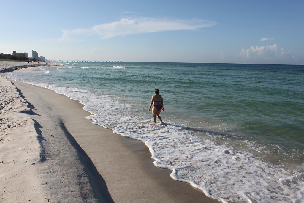
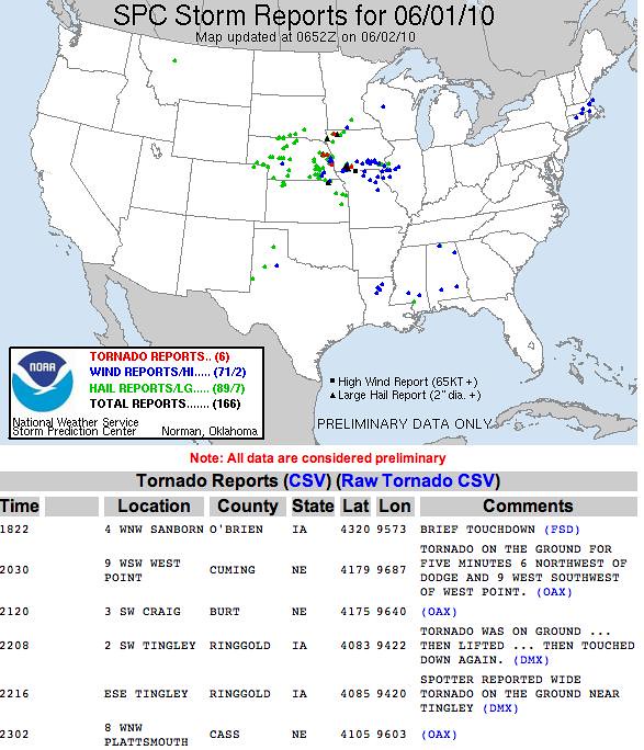
After a fight with my significant other, I had to walk. Walking is my therapy and exercise, or is that exorcise? So I walked. I left home Thursday afternoon about 13:40. I didn't know exactly where I was going at first. Later a goal, materialized, I would walk from our home north of the river to my wife's workplace. I walked first to Riverside. I wanted to cross the Missouri at the Argosy Casino bridge, go into KCK and then cross over into the west bottoms on the Missouri side. It was my first challenge, and I wanted to see if I could do it, or if a lack of pedestrian areas on bridges would hold me back. I mean, Lewis and Clark had no bridges to get across major rivers, but then they never had to deal with 70 plus mile per hour traffic. So with the afternoon sun beating down upon me, I first stopped at the casino for some water and rest from the heat. I never have been in this casino before, so I thought I'd explore. I must say, fancy, and interesting how invisible a person can really be. My experiment and experience was also one of homelessness. I mean, I didn't look like a bum, but leaving home without and ID sort of put me in an invisible status. I had no fear, but I also knew that I could disappear, and no one would know where I went. Invisibility in this society is easy, sometimes easier than existing. People are very good and narrowing their world view to a small focus and reducing everything around them to nothingness except for what their own needs and narcissism would allow. I walked through the casino once, and not a single person looked up or noticed. If I had met some foul play or an accident, I wondered even if some surveillance tape would show up to alleviate the mystery of my whereabouts. I left the casino to cross the grounds to the target bridge. When I got there, it was as expected -- no sidewalks. Pedestrians are a complete afterthought in an automobile society. I thought, what entitlement minded people dreamed up a single use crossing of a major river. How are people expected to cross if they don't have transportation? What if some calamity befell somebody in that they couldn't cross by any other means than by shoe rubber? I guess it is tough luck. The second lesson of homelessness is that you are not only invisible, you do not matter. So shame on these bridges and their designers. I turned around and went back to the casino. I was going to walk the levee around the casino and follow the river all the way to the Broadway bridge, which I knew had walkways. The levee didn't go very far though. It was only built as part of the casino complex in this area, and ended at the park. So, I walked back through the casino, after walking through some areas I'm sure would have attracted security. I came to the park, and walked to the northeast end to see if I could follow the river there. I found a nice beach, but no access beyond the beach. So I walked through the park which was being readied for the highland games, and took the outer road to another park -- Water Wheel park, which was quite busy with baseball games. I took a drink at the water fountain there, and rested my sore feet. Again, I had the sense of invisibility. People were busying themselves with the games and their families and took no notice of me or where I came from. I'm sure some sideways paranoid glances of some middle aged guy who walked into their midst were given, but other than that, I was completely ignored. I rested at a picnic bench, and walked on to take the Broadway extension south. I thought I would try crossing under the overpass, as I was sure the pedestrian situation there was just as dismal. I tried to cross the tracks which the overpass was built to fly over, but found a thicket too intense to cross without a good machete, which I didn't have. I kept thinking that I could run into some malevolent force by the tracks there, and my remains would not be found for years. It is easy to disappear. I got out of the thickets and up on the highway, and found that I really needed a detour, unless I was intent on killing myself. There was no sidewalk, and no shoulder, and the cars flew through there quite fast. Just as I thought that, my invisibilty went away. Someone stopped and gave me a lift over the bridge. I cheated, I thought. I wanted to try to walk the whole way. However, some devine intervention it seemed brought me a guardian angel. I think his name was Dominique. He was hispanic, and had tatoo's and drove a car that spewed smoke and seemed to be on it's last set of tires. I thought, here is a guy that many people probably do not look at twice, and he stopped to help me. A thought kept repeating itself in my head "Jesus is everybody you meet." He gave me a lift and would have driven me all the way into town, but I just asked to be taken across the bridge. I thanked him as best I could, but probably not enough. I walked on the shoulder of 169 south, which was ample, but seemingly not enough for the speed some people were going. Four more cars stopped for me -- two hispanic guys, someone from the middle east, and one caucasian. I thanked them all -- probably not graciously enough, and told them I was wanting to walk. I was beginning to get scarred for them, as their stopping for me could have been more dangerous than my walking alone. However, I do not recommend walking on this highway as a healthy pursuit. Again traffic wins out over pedestrians. I came to the downtown airport, and rested by the terminal. I was not harassed by the 'Barney Fifes'. By this time, I was really feeling my weariness. The temps were in the 80's and humidity was high. I felt a little ill before I rested. I trucked on, across the looming dreaded Broadway Bridge. So now I look up Broadway Bridge in wikipedia, and find....

"The Broadway Bridge is a through arch bridge that spans the Missouri River in Kansas City, Missouri, in the United States. It first opened for traffic September 9, 1956 on U.S. Route 169. It was built at a cost of $12 million dollars. It was a toll bridge until 1991.
It replaced the Second Hannibal Bridge just to its east which had handled auto traffic on its upper level."

http://en.wikipedia.org/wiki/Broadway_Bridge_(Kansas_City)

I have driven, but have never walked the Broadway Bridge. I take that back, I walked it once when there was an accident scene I had to shoot on it, and it was scary then. I knew that it could be walked from that experience, plus I have seen a few pedestrians walk it regularly. However, the walkways on the bridge are not much, and people come at you fast. Some drive so fast, that in the areas where the road curves, they try to cut the corners and close as they can, which means the come very close to hitting you as you walk the walkways. I held onto the railing, and walked fairly confidently. It may not be much here, but it is something. I stopped briefly twice to enjoy the view. I'm sure as I did so, I spotted some drivers on their cell phones probably calling in a 'jumper' to 911. Some were just on their cell phones probably in deference to their safety, pedestrian safety and the safety of other drivers. I saw some hefty looking white guys in an SUV flash big doughy angry looks on their faces, like, how dare somebody be walking on their bridge. I got across safely, finally on the south side of the Missouri, which much more appreciation of rivers and what it took for pioneers to cross them without feats of engineering such as bridges to effortlessly spirit them across. By, this time, I was feeling the soreness of my feet and the churning of my stomach. I needed water. I took a break at the park on the east side of Broadway, that covers the old street car line entrance that took you out to the west bottoms from downtown. I felt sick for a little bit, and, yes, again, quite invisible. I thought about those guys who beg at the north side of the Broadway bridge. I walked to the Quaff, went in, and asked the bartender if I could bother him for a cup of water. He was really nice. He said, "are you kidding, in weather like this, I'm happy to give you some water." It was nice to reappear to someone as a living breathing human being worthy of respect. The Quaff has a new fan. I walked to Bartle Hall, thinking I could refill my cup, which I drained quickly. I walked in the revolving door, which was still open, and spotted a water fountain. I was, however stopped by a security lady, who smiling told me I could go no further without a badge. I told her I was only there to get some water, and she denied me. I said, "are you serious, even though I can see the water fountain you won't let me get a drink?" She just said, "I'm sorry sir." I said, "well I guess that's the way life is." I left thinking that my tax money supports that place, and I can't even go in to get a drink of water. So, I headed south, and I stopped at YJ's. I could go no further. I gave in and called my wife from YJ's. i drank plenty of free water at YJ's, and I know they are quite good to the homeless there, much better even than I am. Jesus is everyone you meet.

Thursday, June 10, 2010

Sever Weather floods our area....

Tuesday turned into an impromtu chase day at work. We were in and documented the worst of the flooding at 103rd and State line and Wornall. During the chase, I noticed convergence on radar of a tvs marker and a meso marker which were going to cross in Cass County. We also saw what looked like a huge dirt dragging wall cloud. I even told my reporter that I thought Cass county was going to get hit. I didn't find out until I read the NWS summary a day later that I was right. A tornado did hit Cass County!
Tue 8 June Pleasant Hill Summary
Harrisonville tornado 6-8-10 radar
Harrisonville tornado radar 2 6-8-10
Harrisonville Tornado damage track 6-8-10
Harrisonville Tornado 6-8-10 Wharehouse
Harrisonville Tornado 6-8-10 Church
Harrisonville Tornado 6-8-10 Caseys
Harrisonville Tornado 6-8-10 Tree
June 8 Flooding
All pictures are from the National Weather Service site at Pleasant Hill, Missouri
Here's a link to a news story on the aftermath of the tornado...
http://www.youtube.com/watch?v=YD3UxhhCriY

Sunday, June 6, 2010

Today is D-Day + 66 years

Please remember....
1st Friday Artwalk, Storm Chasing, I think I even have a train in there too!


Pix from the Keyhole Gallery

Pix from Portraits by David Gant at the Leedy Volkous Gallery

Oh, and a train...

Music at the Fishtank

Friday, June 4, 2010

The problem with corporations is that they are like sharks in the sea.... If you have an ocean full of sharks, it only leads to extinction.
about a minute ago · Comment · Like

Stevo Svoboda

Poverty is the presence of ignorance and greed.
2 minutes ago · Comment · Like

Stevo Svoboda

The problem with a socialist system is that the only boats that get lifted are the ones that couldn't stay afloat in the first place.
36 minutes ago · Comment · Like

Stevo Svoboda

The illusion of the left versus the right is one way that the elites keep the average Joes divided and fighting amongst themselves.
Storm Reports 6-3-10

Barclay Martin, Alamat, April 17, 2010

Wednesday, June 2, 2010

Midwest MCS

Midwest MCS Wed 2 Jun 2010 @ 01-47
Storm Reports 6-1-10
Wednesday 2 June, in the morning, the complex of storms came through bringing heavy rain, light hail and some wind. It wasn't severe warned. The outlook for the aftenoon is for a possibility of severe storms to the south, but the chances are pretty slim.
SPC Wed 2 Jun 2010

Tuesday, June 1, 2010

Blog Archive