
Saturday 23 April 2016 Route 66 Between Carthage and Eureka Springs, Missouri Plus the Gasconade Bridge Rally
Play this playlist for your listening enjoyment while you browse this page....
Some songs are restricted, so watch this on YouTube if'n you can...
Su Casa RV Park in On US 66 in Carthage, Missouri
Nothing like waking up to fresh air and sunshine in the morning. I was having a hard time getting the missus up though...

Video of us Driving Route 66 Westbound in September 2012
RV park complete with original old signage...
 View of the park from the Southeast corner...
 Good Morning! Route 66 greets you and beckons you to move further down the line...
 This is the view roadies dream of...
 Just next door to the 66 Drive In, Carthage Missouri. The Marquee can be seen in the background...
 Looking east towards Carthage, Missouri on Route 66.
 66 Drive-in Theater as seen from across the street at Mi Casa RV Park.
 It is a cool morning, but the suns rays are warming things up nicely...
 Mi Casa RV Park.
http://www.carthagepress.com/article/20151007/NEWS/151009219
 Dawgs enjoying the grass on a cool April Morning at Mi Casa RV Park on Route 66 in Carthage, Missouri
 Dawgs!
 Carthage, Missouri to Gay Parita
Dashcam footage from August 2013 of Route 66 in this area...
The first stop is right next door to where we begin this adventure. Well, it is not so much a stop as it is a photo opportunity. The route 66 Drive-in in Carthage Missouri is an icon of the road in a time when such theaters are so rare that coming upon one is a treat. There is a little gravel shoulder across the street where we quickly pulled over and snapped a few photo's.
https://www.facebook.com/66-Drive-In-Theatre-98931385414/
http://66drivein.com
 Here is a video of the Carthage area and the drive-in from 2012...
 Love the marquee....
 and the glass block ticket taker window...


 Departing Mi Casa RV park heading east on Old 66 Boulevard towards Carthage, Missouri. We pass the Route 66 Drive-In, an Icon of the road. 66 from here is fairly straight forward. It is fairly clearly marked by Blue Historic 66 signs that are unique to the state of Missouri.
.svg/2000px-US_66_(MO_historic_byway).svg.png)
66 bends to the northeast then straight east, where is becomes a 4 lane divided highway (sort of) a narrow one.
 You cross over I-49, which fairly recently was US 71, both roads are descendant roads of the Jefferson Highway...


Jefferson Highway was also a parent road for parts of Route 66.
Crossing over I-49, Route 66 is also known as Oak Street in the west part of Carthage.
 An interesting feature of Route 66 in Carthage is what is jokingly referred to as a "bump" bridge. This bridge crossed over the Missouri Pacific (MoPac) tracks during the 66 era, but is now crossing over the Missouri and Northern Arkansas Railroad.


As to why it is called a bump bridge, simply look at the dash cam photo. However, if that doesn't tell you, then please dare not to take this bridge too fast you will find yourself airborne, much to the chagrin of your cars suspension, your wallet and possibly your own health. Some people also refer to this as the wee bridge for the same reasons. Unfortunately, this piece of history, I think is slated for destruction. Here is a video from Roamin' Rich...
https://youtu.be/l5F-VnJt-kM
 After the wee bridge, as you head east, look to your right. There is an old sign for an auto division of Chrysler that hasn't existed since the early 60's. If you remember the tv show "Happy Days" De Soto was the butt of jokes on the program as the father in the show drove and old De Soto.
 In the photo below, a unique Missouri Historic 66 sign can be seen. We are coming to a T-Intesection where Oak Street meets up with Garrison Avenue. A left will be taken here, and we will find ourselves traveling North.
 And here is another great icon of the Mother road. On our right side as we are traveling north here is the old Boots Drive in restaurant. It has been preserved as an auto bank building. To our left is the Boots Courts, which is a streamline moderne Motel with a rich history.
http://bootsmotel.homestead.com/index.html
 Barely have we been driving north than we have to turn right (after about 2 blocks) on Central Avenue to head east out of Carthage. If you have time, stop downtown and visit the courthouse square. It is a nice place to stop and walk, tour some antique stores or see some really good art. Also, if you are of a mind to and are very curios, stop and visit the Boots Court. They are more than happy to give a tour. Better yet, if you are coming to a close to your days journey, wherever you are traveling, make a point to book a room there.
 As you head east out of Carthage, you will see some curious artwork in the form of sculptures. Chances are these are done by one of Carthage's famous resident artists, Lowell Davis. http://www.redoakiimissouri.com
 The mother road bends to the northeast and after crossing over a bridge over some railroad tracks you find Carthage is now in your rearview mirror. The previously mentioned artist, Lowell Davis has nice little friendly stop that is just a few miles north of Route 66, but still close enough to be considered a Route 66 attraction -- Red Oak II. When we used to visit Gary Turner at Gay Parita, he would always recommend a visit to Red Oak II. When we finally listened to Gary, we were rewarded with one of Route 66's hidden treasures.
Here is a video from that visit in December 2013
 Crossing over another bridge eastward, on a scenic exit from town, you come to a junction with the Kel Lake motel. Now, while it is perfectly acceptable to stay on this road and head straight east as you are on a later alignment of Route 66, which in these parts is Missouri 96, there is a more interesting detour here, which is an earlier alignment, aptly called Old 66 Boulevard. We chose to turn right on Old 66 Boulevard and take the old way. Also as you cross over the bridge, you will see over to your right (heading east) the remains of an older bridge, which was route 66's earlier entry into town.
 Old 66 Boulevard detour will not last too long, but you will see some interesting old court motels and some cool signs as well as some portland narrow 66 highway.

 Re-uniting with Missouri 96, continue on east, but take note on your left you will see some original sidewalk highway...

 Somewhere here is the turn off for Red Oak II. Look for the sign to your left. You will pass through small towns where time has stood still, like Avilla, Missouri


 Avilla, Missouri
 I include screen grabs of our progress to help me remember as I do not fill in the commentary on my web logs as I travel, but often weeks or even months later. Also, if you keep note of the time stamp, you can sort of figure how long it takes to travel these parts. On this day, Saturday, we did a rush tour of 66 as we had to be at the rally at the Gasconade Bridge. Having a late start, our appointment with the rally was imperiled.
 East on Missouri 96, formerly US 66.


 I call this area the movie set part of route 66 in Missouri. There are a few spots on the road where if you blocked the more modern stretch of road, you could envision yourself on old US 66 in it's heyday. If any hollywood types want to make a route 66 themed movie, please check out this stretch in Missouri. With a little paint and vintage cars, you can have a cheap movie set.

 Funny enough, I look on the map, and this area is called Albatross. This is south of the town of Miller...
 The ozark stone used in many buildings in this area is a unique feature of this stretch of road. Keep your eyes out for many ruins in this area -- old gas stations, cafe's, and court motels.

 Once again... ruins....
 .... and more ruins...
 As we travel east, here is a link to what is called Giraffe Stone, which I just found out by doing a google search...
https://alongroute66.wordpress.com/tag/giraffe-stone-architecture/
 After traveling eastward for what seems like a long time, look for a road marked Lawrence 2062. This road is before the turn off to Paris Springs/Gay Parita. You will pleasantly find yourself on concrete road that is timeless, but that is not the main attraction of this old alignment of 66. The small restored town of Spencer is your goal, and yes, you will swear you made your way onto a time machine....

 Spencer, Missouri
Imagine our van Melba as a magical time machine that took us back to the 1940's. The real magic is in the love and the time that people all along Route 66 have poured into restoring portions of the road.
Here is a video we took in July 2012
 Portland concrete highway...
 Melba pays a visit back in time...

 The bridge at the east end of Spencer adds to the nostalgia overload...


 If only....
 12 cents? Filler up!!!
 I could use a cold drink and a slice of pie right now. What? you've never heard of sugar free????
 Still a work in progress on the inside....

 History pasted on the windows. Take time to read up...

 I could use a shave and a hair cut... is it two bits?

 Lots of farmers in this area..
 Dawgs making the most of a shady respite...
 Anyone in search of a ready made movie set?
 66 on 66....


 Time for our next and most melancholy stop....


 After Spencer, cross the little truss bridge, and hang a left on Missouri N. You are now traveling northeast. Carefully cross over 96 looking both ways as the 96 traffic is at highway speeds. Once you cross over, you are now on Missouri 266.

266 is rather scenic in the spring time.
 Another treat is the pony truss bridge you find here on 266.
 Gay Parita
http://garysgayparita.com
Video from October 2012...
Not enough can be said of Gary Turner. He passed away in January 2015.
http://theotherroad66.blogspot.com/2015/01/friends-for-life.html
Gay Parita in August 2014
Gary Passed from this world in January 2015 and he is forever in our hearts.
The Ambassador of Route 66....
 https://www.facebook.com/gay-parita-sinclair-186023720950/?ref=ts
 https://www.facebook.com/groups/221539858355/


 Gay Parita's torch has passed on to family, who, hopefully will continue keeping Gary's light shining for all weary roadies and travelers....
Raw Footage from the August 2013 Route 66 Festival
 Paris Springs, Missouri to the Gasconade River
 After the shortest visit we've ever had to Gay Parita, we continue our journey eastward on Missouri 266.
 Another movie set town .. Halltown, Missouri


 And east we go on 266....
 ... more giraffe stone....
 A time locked gas station....

 and another time locked station...
 Springfield, Missouri
266 broadens to four lanes and crosses under a railroad bridge as a gateway to Springfield Missouri, which claims to be the birthplace of 66.

 ...and begins the iconic googie signage from the 50's and 60's that dot the roadscape of old US highways. Don't know what googie is???? Weeeeellllll let me tell ya!!!
Or better yet, let the experts tell you....

http://www.spaceagecity.com/googie/
https://www.laconservancy.org/architectural-style/googie
http://la.curbed.com/2015/1/16/10001398/an-introduction-to-googie-socals-signature-architectural-style
Here is a documentary on Googie in LA...
https://youtu.be/oEnaPtsP0ls
Part 2...
https://youtu.be/TfB3m50QchU
 In western Springfield Route 66 is West Chestnut until it splits into a big Y intersection. Now technically, both parts of the Y were at one time the route, the southern portion of the Y, or West College street is most interesting in many respects due to the architecture and the fact that it goes through downtown. Spend some time in Springfield and explore the different branches of the route.
 Love the Wishing Well sign...
 Heading east on West Chestnut in Springfield, Missouri

 The big Y intersection where we need to take the southern branch of the Y, or West College Street.

 Here the architecture quickly turns to small cottages and old court motels.
 Shamrock Court
https://www.facebook.com/pages/Shamrock-Court-Springfiled-Mo/538269722939452
https://www.instagram.com/p/9u6XdNt0WG/
 Tubby's Diner
http://www.tubbysdiner.com
https://www.facebook.com/Tubbys-Diner-171536322974526/
 College Street Body Shop
http://www.collegestreetbodyshop.com
https://www.facebook.com/College-Street-Body-Shop-120862824614951/
 Continuing east on College Street in Springfield, Missouri
 College Street Cafe
https://sgfdinersanddives.wordpress.com/reviews-3/poppys-college-street-cafe/
 A recent victim of neglect, a former antique mall existed here but has died a sad death by wrecking ball....
http://millpictures.com/mills.php?millid=411
 Most of the railroad tracks in the area belong to what was once the hometown Railroad -- the Frisco...
Reds Giant Hamburg
Music video shot at Red's
https://youtu.be/cfs-TFt96T0
Birthplace of 66 Park
http://www.route66festivalsgf.com/ptpark.html
 The mural in the rock wall to the right in this picture has been here a long time....
http://www.route66festivalsgf.com/ptmural.html

 As we approach downtown Springfield, things start to get busier....

 Downtown Springfield, Missouri

 Springfield, being the home of several colleges is filled with coffee shops and bars. If you are so inclined, it is a good entertaining night spot stop.

 You head east on college until you hit Park Central Square. Park Central Square is a one way surrounding a park. College street magically morphs into Park Central street west and east, then into East St. Louis Street.
 Shortly after passing the Park Central Square, you come upon a great Route 66 landmark, which I have found is better viewed coming from west to east...
http://www.theshrinemosqueonline.com
https://en.wikipedia.org/wiki/Abou_Ben_Adhem_Shrine_Mosque


 East on St. Louis Street

 No time for vittles today, but I love stopping at the original Steak -N Shake in Springfield...
https://www.facebook.com/Steak-N-Shake-Cruise-Ins-Springfield-MO-1488629641456279/
 I saw this set up shot at a stop light with Jimmy in the foreground and the Springfield sign in the back ground. On our trip here in 2004, we stayed in the Rail Haven Motel -- it is a nice place...
http://hotelsinspringfieldmo-route66.h.bestwestern.com
 Sometimes you see old abandoned derelict signs from the googie era, meanwhile, these signs in antique stores fetch thousands of dollars.
 A city that takes pride in its route 66 heritage.


 East St. Louis Street meets North Glenstone Avenue in eastern Springfield, turn left at the light and head north on North Glenstone.
 We had pasty's in England. I have heard, but not confirmed that these served here in Springfield are just as good....
http://www.londoncallingpastycompany.com

 Video from June 2015 of Bennett Spring and Route 66...
 Glenstone Court Motel
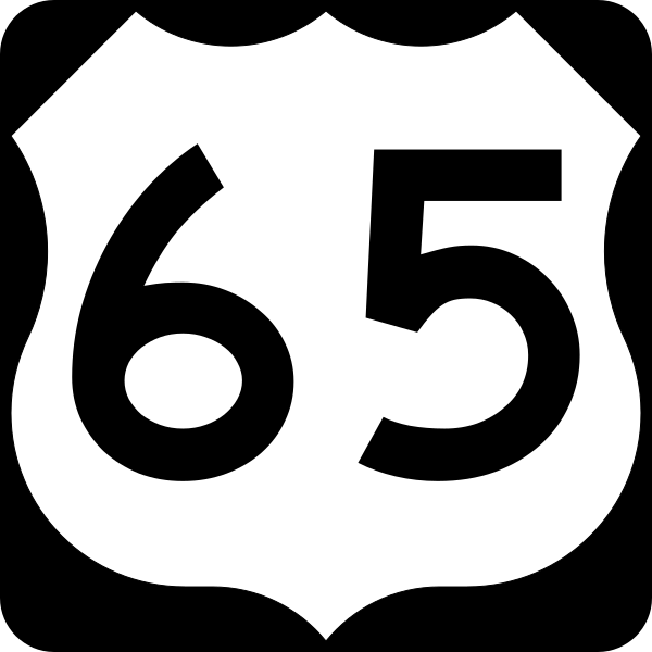
 North on Glenstone which is Business US 65 to East Kearney Street, turn right to head east out of town. You have to be patient with Glenstone -- lots of traffic and plenty of lights. It is hard to get across the street if there is no light as there is a lot of traffic.
 Rest Haven Court Motel. This neon sign is very iconic 66. It is similar in design to the Munger Moss Motel as well as the Holiday Inn signs.
https://www.facebook.com/pages/Rest-Haven-Court/117478108272103
Not really related, but perhaps... Holiday Inn and it's sign
http://www.salon.com/2002/04/29/holiday_inn/
 East on East Kearney/ Missouri 744, you pass some abandoned court motel cabins (Victory Court) and an old drive-in theater that is abandoned....
http://www.route66university.com/photos/postcard_36/slides/victory_sprmo.html

Route 66 follows East Kearney street straight east then meanders to the northeast by east.

 There are parallel railroad tracks to the south of the route.
 Which brings us to the town of Strafford, Missouri. There is not much of a downtown but some big truck stops service the Interstate and the eastern gateway of Springfield.


 After Strafford, route 66, also known as oo, becomes an outer road, with I-44 on the north side and train tracks on the south.

 The tracks are former Frisco tracks to St. Louis, now Burlington Northern Santa Fe.

 The Missouri Wild Animal Safari is an attraction on Route 66 here...

 The road mostly parallels the Interstate here and meanders to the Northeast. The distinct Blue Missouri 66 signs generally keep you on track.


 We make it to Marshfield Missouri for a much needed pit stop and fuel break.


 After the pit stop, we make our way, just about a block east of the Casey's to a Y in the road. The Y is West Jackson, which takes you into the town of Marshfield, and West Hubble road, which is the continuation of route 66. We need to stay to the left to take West Hubble.


 Route 66 Bridge across the Niangua River.
http://bridgehunter.com/mo/webster/niangua-66/

 The road cuts in Missouri can be very dramatic as this area is part of the hilly Ozarks.
 We pass but don't go into the small town of Niangua


 Driving east/northeast through Conway Missouri on Route CC.

 Traveling northeast on CC
 Route CC eventually rejoins the Interstate as the south outer road before coming to Phillipsburg. At Phillipsburg, Turn right onto Pine street, and cross over the Interstate. There, you will come to route W, and turn right and continue Northeast on the north outer road.
 After crossing over the interstate at Phillipsburg, we cross under the Burlington Northern Santa Fe Railway.
 Continue northeast on the north outer road marked as route W.


 Dashcam Time-lapse from June 2015 From Lebanon Westbound on Route 66...
Turn left at the light to head north into town on West Elm Street.
 One of the sights you will see if you look off to the right is the Humpin' to Please mural.
http://campbell66express.com/


 Route 66 continues north in Lebanon on West Elm Street, then bends to the northeast...
 At a stoplight, you cross the main drag in town, which is South Jefferson Avenue.
 Heading northeast, the route bends to the east at Millcreek Road.


 A left is made off of Millcreek Road onto Pecos Drive, which heads northeast. This interesting part of the route includes Munger Moss Motel.
 http://www.mungermoss.com/
 Munger Moss from July 2012


 Peaches Drive heads northeast and becomes the north outer road of I-44.


 We continued east towards our goal when we were stopped by an unexpected sight -- there was a bald eagle in the middle of the road. Wouldn't you know, when I stopped to get it's picture, it flew into the trees. I attempted to get a shot. Somewhere in there in the picture is the bald eagle.

 We knew we were getting close to the rally as we kept passing many vintage cars heading the other way.


 Gasconade River Bridge Rally
We somehow found close parking.
 Passing a 56 Chevy convertible on the way to the rally.


 The rally is well attended.

 The lectern for the rally -- Roamin' Rich's adventure truck with a trailer for a stage.
 Roamin' Rich Dinkela, Master of ceremonies for the Gasconade Bridge Rally


 Jax Wellborne, of Pix By Jax
https://www.facebook.com/picsbyjax/


 Departing the rally, we had to backtrack crossing at route T, and, unfortunately, we got on the interstate for the first time on this trip...

That is because route 66 is blocked by some bridge needing repair or something...


 We only took this necessary evil until we hit the Mo 133 exit. We got off the freeway and turned left to head northeast on route AB.
 This route pleasantly meanders through the countryside.


 But then the modern world intrudes. We have to cross over the interstate to get on the north side and the north outer road otherwise known as Missouri route 17.

 Following Missouri Route 17 past a giant bowling pin north of I-44.


 Missouri 17 heads north out of Waynesville at an intersection downtown. We will continue to head straight on Route 66, and not follow Missouri 17 which makes a left turn downtown off of 66. After Waynesville, we find ourselves in the Fort Leonard Wood area, which is a major army training post.


 Route 66 is fairly clearly marked through the Fort Leonard Wood area. It becomes the south outer road of I-44 for a stretch, before arriving at the Hooker Cut. At the cut, you can choose to follow that interesting segment all the way, or you can turn right on Teardrop Road, which will take you down to the Big Piney River and Devils Elbow.
 Turn off on Teardrop Road


 Devils Elbow, Missouri

 Crossing the bridge over the Big Piney River


 The biker bar here is called Elbow Inn -- get it?
https://www.facebook.com/ELBOW-INN-BAR-BBQ-203025669029/
 The Devils Elbow alignment rejoins the hooker cut north of the Elbow Inn. Turn right to head east on Missouri route Z.

 Hooker Cut is spectacular and has almost an eerie abandoned feel to it.


 At Missouri Route J, A left is made to cross over the Interstate, then an immediate right to continue on the outer road, north of the Interstate. This is called the North Outer Road or Powellville Road.
 We were supposed to turn off at route 7570 at Smith Hollow to join I-49 northeast for part of the route, but we made an inadvertent but interesting detour north to Jerome, Missouri.


 After backtracking, and finding the exit, we found ourselves on the Interstate through a scenic hilly area.

 Our turn off came not soon enough on 7300 road. Eventually the became Eisenhower Street coming into Doolittle, Missouri.


 Eisenhower Street becomes route 7100 and meanders through some pretty country.


 The route becomes the south outer road of I-44 before coming into Rolla.

 There are many fine examples of roadside googie here.

 The outer road meets up with a traffic circle, take the first right to join up with Kings Highway into Rolla.


 In Rolla, turn left on North Bishop Avenue/US 63 to head north.

The route passes to the west of downtown Rolla and skirts the west edge of the Missouri University of Science and Technology campus. The university here is an engineering college.
 Again, the roadside architecture on the northwest side of Rolla tends towards the space age themes of googie.


 Take US 63 north across the interstate overpass, and look to the right for Historic US 66. Take that exit to head east northeast.
 Eventually the route becomes the north outer road for I-44. This stays this way for quite a ways before coming to St. James, Missouri.


 The north outer road intersects N. Jefferson Street/Historic 66. After a long light, we turn right and head southeast. A left is made on Historic US 66, and we continue on Northeast.


 Eastbound on Historic US 66.

 We made a photo stop at Fanning 66 Outpost -- home of the world's biggest Rocker...
http://www.fanning66outpost.com/


 So far we have made our way across most of Route 66 in Missouri.

 Route 66 through here is route ZZ
 Historic 66 goes straight through town.


 Wagon Wheel from September 2012

 Northeast of town, the road curves to the northeast paralleling the BNSF railroad tracks.


 Eventually the route becomes the south outer road of I-44 before arriving at Bourbon. Be sure to get a picture of a water tower with the word Bourbon on it.


 Through Bourbon the road is called Historic US 66 as it has been for miles. That is convenient!
 That's a lot of Bourbon!


 Historic 66 becomes again the south outer road of I-44.

 As Historic 66 comes into the town of Sullivan, it becomes west Springfield Road.


 We followed West Springfield road as it becomes East Springfield Road through Sullivan and out to the northeast as it becomes yet again an outer road of I-44 labeled North Service Road East. However, I think we should have turned left on Missouri route 185, crossed the highway, and taken a right on North Service Road West otherwise known as Historic 66. That would have taken us on the north side of the highway which to an overpass that we came to later, anyway.


 At Stanton, we broke Karma with the road and took I-44 instead of following the north outer road. In Stanton, there are some interesting abandoned motels. It looks like the area hit on hard times.
 We continued breaking karma with the road until we hit the St. Clair exit.
 At St. Clair, we turned right on Historic US 66, then left on West Gravois Avenue, then left to head northeast on North Commercial Avenue.

 We again broke karma with the road on the next exit northeast of St. Clair to bypass the route 66 north outer road of I-44 through here.

 We exited at route O after crossing the Bourbeuse River. We turned left to go under the I-44 overpass, then turned right on route AT/Historic US 66 to the northeast. This meanders through some pretty countryside until we find ourselves at a sadly abandoned iconic route 66 landmark, the old Diamonds Truck stop.


 Diamonds truck stop looking forlorn and deserted...
http://www.route66university.com/busdir/diamonds.php
 This building may be reopening in October as an auction house...


 Here AT joins up with Missouri Route 100

 https://www.facebook.com/TriCountyTruckStop/
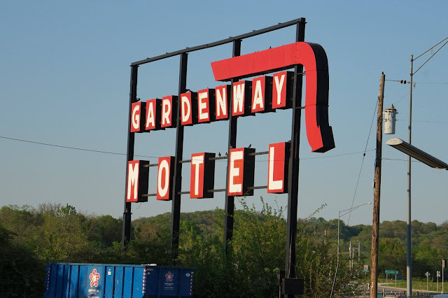
 Missouri 100 meanders across I-44 and it crosses the intersection where the Diamonds moved to with the big Gardenway Motel.

 Gardenway Motel


 We headed eastbound on a great stretch of Route 66. It becomes Osage Street through Pacific, Missouri.


 East Osage Street out of Pacific becomes Business Loop 44. We made our way to our final destination for the day, the huge KOA campground east of Pacific.


 Unique bluffs overlooking Pacific.


 Turning into the KOA campground.


http://koa.com/campgrounds/st-louis-west/


 There's a cemetery next to our KOA!


Play this playlist for your listening enjoyment while you browse this page....
Some songs are restricted, so watch this on YouTube if'n you can...
Su Casa RV Park in On US 66 in Carthage, Missouri
Nothing like waking up to fresh air and sunshine in the morning. I was having a hard time getting the missus up though...
Video of us Driving Route 66 Westbound in September 2012
RV park complete with original old signage...
http://www.carthagepress.com/article/20151007/NEWS/151009219
Dashcam footage from August 2013 of Route 66 in this area...
The first stop is right next door to where we begin this adventure. Well, it is not so much a stop as it is a photo opportunity. The route 66 Drive-in in Carthage Missouri is an icon of the road in a time when such theaters are so rare that coming upon one is a treat. There is a little gravel shoulder across the street where we quickly pulled over and snapped a few photo's.
https://www.facebook.com/66-Drive-In-Theatre-98931385414/
http://66drivein.com
66 bends to the northeast then straight east, where is becomes a 4 lane divided highway (sort of) a narrow one.
Jefferson Highway was also a parent road for parts of Route 66.
Crossing over I-49, Route 66 is also known as Oak Street in the west part of Carthage.
As to why it is called a bump bridge, simply look at the dash cam photo. However, if that doesn't tell you, then please dare not to take this bridge too fast you will find yourself airborne, much to the chagrin of your cars suspension, your wallet and possibly your own health. Some people also refer to this as the wee bridge for the same reasons. Unfortunately, this piece of history, I think is slated for destruction. Here is a video from Roamin' Rich...
https://youtu.be/l5F-VnJt-kM
http://bootsmotel.homestead.com/index.html
Here is a video from that visit in December 2013
Avilla, Missouri
From Wikipedia, the free encyclopedia
Miller, Missouri
From Wikipedia, the free encyclopedia
https://alongroute66.wordpress.com/tag/giraffe-stone-architecture/
Spencer, Missouri
From Wikipedia, the free encyclopedia
Imagine our van Melba as a magical time machine that took us back to the 1940's. The real magic is in the love and the time that people all along Route 66 have poured into restoring portions of the road.
Here is a video we took in July 2012
266 is rather scenic in the spring time.
http://garysgayparita.com
Video from October 2012...
Not enough can be said of Gary Turner. He passed away in January 2015.
http://theotherroad66.blogspot.com/2015/01/friends-for-life.html
Gay Parita in August 2014
Gary Passed from this world in January 2015 and he is forever in our hearts.
The Ambassador of Route 66....
Raw Footage from the August 2013 Route 66 Festival
Paris Springs Junction, Missouri
From Wikipedia, the free encyclopedia
Halltown, Missouri
From Wikipedia, the free encyclopedia
266 broadens to four lanes and crosses under a railroad bridge as a gateway to Springfield Missouri, which claims to be the birthplace of 66.
Or better yet, let the experts tell you....
http://www.spaceagecity.com/googie/
https://www.laconservancy.org/architectural-style/googie
http://la.curbed.com/2015/1/16/10001398/an-introduction-to-googie-socals-signature-architectural-style
Here is a documentary on Googie in LA...
https://youtu.be/oEnaPtsP0ls
Part 2...
https://youtu.be/TfB3m50QchU
https://www.facebook.com/pages/Shamrock-Court-Springfiled-Mo/538269722939452
https://www.instagram.com/p/9u6XdNt0WG/
http://www.tubbysdiner.com
https://www.facebook.com/Tubbys-Diner-171536322974526/
http://www.collegestreetbodyshop.com
https://www.facebook.com/College-Street-Body-Shop-120862824614951/
https://sgfdinersanddives.wordpress.com/reviews-3/poppys-college-street-cafe/
http://millpictures.com/mills.php?millid=411
St. Louis–San Francisco Railway
Route 66 Park, which is recent...Reds Giant Hamburg
Music video shot at Red's
https://youtu.be/cfs-TFt96T0
Birthplace of 66 Park
http://www.route66festivalsgf.com/ptpark.html
http://www.route66festivalsgf.com/ptmural.html
http://www.theshrinemosqueonline.com
https://en.wikipedia.org/wiki/Abou_Ben_Adhem_Shrine_Mosque
https://www.facebook.com/Steak-N-Shake-Cruise-Ins-Springfield-MO-1488629641456279/
http://hotelsinspringfieldmo-route66.h.bestwestern.com
http://www.londoncallingpastycompany.com
https://www.facebook.com/pages/Rest-Haven-Court/117478108272103
Not really related, but perhaps... Holiday Inn and it's sign
http://www.salon.com/2002/04/29/holiday_inn/
http://www.route66university.com/photos/postcard_36/slides/victory_sprmo.html
Route 66 follows East Kearney street straight east then meanders to the northeast by east.
Strafford, Missouri
From Wikipedia, the free encyclopedia

Marshfield, Missouri
From Wikipedia, the free encyclopedia
West Hubble road becomes route CC as it heads northeast.
The route bypasses downtown and skirts around the north side of Marshfield before continuing on to the north east. Here it meanders through pretty farm country.http://bridgehunter.com/mo/webster/niangua-66/
Niangua, Missouri
From Wikipedia, the free encyclopedia
The road bends to the north from here.
Conway, Missouri
From Wikipedia, the free encyclopedia
Phillipsburg, Missouri
From Wikipedia, the free encyclopedia
Lebanon, Missouri
From Wikipedia, the free encyclopedia
Traveling northeast on route W, the route becomes West Elm Street as you enter Lebanon. The route comes to a stop light at a busy interchange on the south side of town where a big old truck stop is.
Turn left at the light to head north into town on West Elm Street.
http://campbell66express.com/
We follow Pecos Drive Northeast to an overpass over I-44 at route F. We cross over and turn left on Glacier Point Road. On this day we are close to our goal of reaching and attending the Gasconade Bridge Rally.
We somehow found close parking.
https://www.facebook.com/picsbyjax/
That is because route 66 is blocked by some bridge needing repair or something...

Waynesville, Missouri
Fort Leonard Wood (military base)
From Wikipedia, the free encyclopedia
Devils Elbow, Missouri
From Wikipedia, the free encyclopedia
https://www.facebook.com/ELBOW-INN-BAR-BBQ-203025669029/
Jerome, Missouri
From Wikipedia, the free encyclopedia
In this area we passed by the Trail of Tears Memorial
Doolittle, Missouri
From Wikipedia, the free encyclopedia
Rolla, Missouri
From Wikipedia, the free encyclopedia

The route passes to the west of downtown Rolla and skirts the west edge of the Missouri University of Science and Technology campus. The university here is an engineering college.
St. James, Missouri
From Wikipedia, the free encyclopedia
http://www.fanning66outpost.com/
Cuba, Missouri
From Wikipedia, the free encyclopedia
Sullivan, Missouri
From Wikipedia, the free encyclopedia
Stanton, Missouri
From Wikipedia, the free encyclopedia
Saint Clair, Missouri
From Wikipedia, the free encyclopedia
Saint Clair is famous for it's twin water towers that are marked hot and cold.
http://www.route66university.com/busdir/diamonds.php

Pacific, Missouri
From Wikipedia, the free encyclopedia
http://koa.com/campgrounds/st-louis-west/
No comments:
Post a Comment